|
NEWS FROM WATERSHED MANAGEMENT
San Gabriel River Master Plan
|
| June 2001 Issue |
|
In September of 1999, The Board of Supervisor's passed a motion
requesting Public Works to develop the San Gabriel River Master Plan
(SGRMP). Watershed Management Division is currently leading the effort.
 Upon the tentative completion date of 2003, the SGRMP will be a
consensus-based plan that will recognize and address river issues
and concerns of the stakeholders. The plan will advocate enhancements
for recreation, open space, and habitat areas, preservation of the
river's natural resources while maintaining the current flood protection
and water conservation.
Upon the tentative completion date of 2003, the SGRMP will be a
consensus-based plan that will recognize and address river issues
and concerns of the stakeholders. The plan will advocate enhancements
for recreation, open space, and habitat areas, preservation of the
river's natural resources while maintaining the current flood protection
and water conservation.
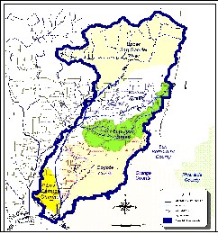
The SGRMP will cover the San Gabriel River corridor
from Morris Dam in the San Gabriel Mountains to the River's outlet in
Seal Beach. The River's corridor is 37 miles in length with many
opportunities for enhancement. This provides the San Gabriel River a
unique opportunity to become a vibrant natural greenway, while providing
flood protection and water conservtion.
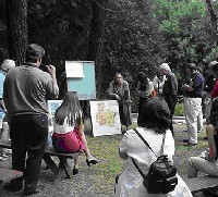
 The Master Plan has already accomplished some important milestones. The
development of the plan is being guided by a group of stakeholders. These
stakeholders include cities adjacent to the River, regulatory agencies,
water professionals, and interested community and environmental groups.
The Master Plan has already accomplished some important milestones. The
development of the plan is being guided by a group of stakeholders. These
stakeholders include cities adjacent to the River, regulatory agencies,
water professionals, and interested community and environmental groups.
The steering committee/stakeholders completed an extensive information
exchange process to better understand each other's responsibilities and
involvement relating to the river.
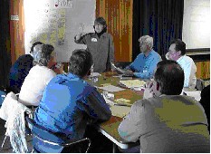
The steering committee/stakeholders worked together through several
workshops to identify goals and objectives for open space, recreation,
and habitat. These goals and objectives are currently being used to develop
a vision for the River.
 A website has also been developed to keep pertinent information
available regarding plan progress, meeting agendas, membership lists, and important
website links. The site address to the San Gabriel River website is:
http://www.dpw.co.la.ca.us/wmd/watershed/sg/mp/.
The San Gabriel Watershed encompasses approximately 640 square miles of
land in the eastern portion of Los Angeles County. The San Gabriel
Watershed has a wide variety of terrain. This includes the mountains of
the northern region, the low-lying foothills, the valleys, and the coastal
plain. The San Gabriel River Watershed is comprised of four major sub-watersheds.
They are Walnut Creek, San Jose Creek, Coyote Creek, and the Upper San Gabriel
River Watersheds. The SGRMP will ultimately be an integral part of the whole
San Gabriel River Watershed planning effort.
A website has also been developed to keep pertinent information
available regarding plan progress, meeting agendas, membership lists, and important
website links. The site address to the San Gabriel River website is:
http://www.dpw.co.la.ca.us/wmd/watershed/sg/mp/.
The San Gabriel Watershed encompasses approximately 640 square miles of
land in the eastern portion of Los Angeles County. The San Gabriel
Watershed has a wide variety of terrain. This includes the mountains of
the northern region, the low-lying foothills, the valleys, and the coastal
plain. The San Gabriel River Watershed is comprised of four major sub-watersheds.
They are Walnut Creek, San Jose Creek, Coyote Creek, and the Upper San Gabriel
River Watersheds. The SGRMP will ultimately be an integral part of the whole
San Gabriel River Watershed planning effort.

|